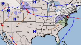
After a brief glimpse of springtime weather, the Granite State will once again feel the chill.
That’s according to Meteorologist Rob St. Pierre of Hometown Forecast Services. He says to expect freezing daytime temperatures statewide for the first half of the work week. St. Pierre says the so-called “Polar Vortex”-- a mass of arctic cold air that wraps itself around high pressure systems and cold fronts—is to blame for the long, harsh winter. And we can expect more cold snaps until the air mass retreats northward.
“It looks like it’s going to be a gradual process. Ordinarily, we expect springtime temperatures in a typical year around springtime or maybe a week after that," St. Pierre says. "But we may be stuck in this cooler weather for the rest of the month. And we may have to wait until maybe early April for temperatures to warm up.”
He says we’re also in something of a cold weather Catch-22. Colder temperatures will likely slow the melting of snow cover until April. But so much snow pack on the ground makes it difficult for temperatures to finally warm up.
Things should start to warm up on Wednesday before another cold front moves in. And by Thursday and Friday, we should be closer to seasonable highs in the 40s.


